Published study · Rainfall projections
A dip, then a recovery: rainfall futures in Beni–Irumu
Under a high-emissions future, rainfall in the Beni–Irumu region of eastern DR Congo is projected to fall in the coming decades and recover later in the century. One place, Oicha, stays drier throughout.
Read the published paper ↗- Historical baseline
- 32 years
- Locations analysed
- 14
- Wettest vs driest, historical
- 1,768 vs 864 mm / year
- Largest near-term decline, Oicha
- −566 mm / year
How to read these numbers: all projections follow SSP5-8.5, a high-emissions pathway, and compare each future period with the 1983–2014 baseline. Mount Stanley is the wettest location and Kasenyi the driest.
Why project rainfall here?
The Beni and Irumu territories span North Kivu and Ituri provinces, rising from about 609 m along the Semuliki River to more than 4,800 m on the Rwenzori. Traditional farming is the main livelihood and depends on rainfall, but earlier studies relied on a few rain gauges and could not show how rainfall varies across such a varied landscape, or how it might change.
Satellite rainfall and two climate models
The study used CHIRPS rainfall at 0.05° resolution for 14 virtual stations to describe the 1983–2014 baseline. Two CMIP6 models, GFDL-ESM4 and INM-CM5-0, were bias-corrected to CHIRPS with gamma distribution mapping and averaged into an ensemble, which reproduced the observed mean closely (1,315.56 mm simulated against 1,306.13 mm observed; percent bias 0.72%). Projections under SSP5-8.5 covered 2026–2050, 2051–2075 and 2076–2100, analysed with Mann-Kendall trends and the standardised precipitation index (SPI).
- CHIRPS · 0.05°
- CMIP6 · GFDL-ESM4 · INM-CM5-0
- Distribution mapping
- Mann-Kendall · SPI
03 / Findings
Three periods, one persistent gap
Mountains wet, plains dry
Historically, Mount Stanley receives the most rain (1,767.87 ± 174.41 mm a year) and Kasenyi, near Lake Albert, the least (863.65 ± 81.85 mm). The projections keep this orographic pattern in every period.
A near-term dip
For 2026–2050, rainfall falls almost everywhere: by 565.55 mm a year in Oicha, 323.45 mm in Maboya, 296.58 mm in Kamango and 251.25 mm in Bulongo. Kasindi/Yihunga changes least, at −58.5 mm.
Recovery, except in Oicha
Rainfall begins to recover from mid-century, and by 2076–2100 most locations are above the baseline, led by Kasindi/Yihunga at +329.7 mm. Oicha remains below it: −417.48 mm in 2051–2075 and −313.82 mm in 2076–2100.
Dry years still arrive
The SPI shows severe dry years in 1984, 1991, 2002, 2003 and 2009. Under SSP5-8.5, severe dry conditions are projected across almost the whole region in 2026, 2031 and 2046, and again in 2052, 2055, 2058, 2077 and 2080.
Read the projections
How annual rainfall shifts from the historical baseline
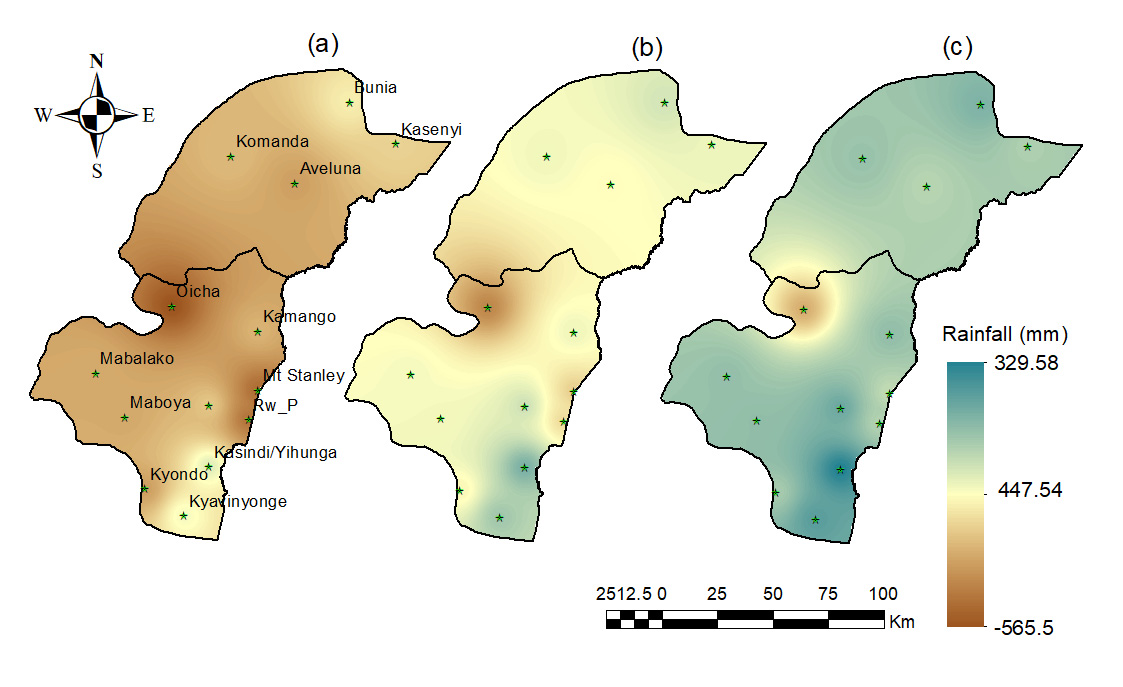
Difference between projected and historical (1983–2014) annual rainfall under SSP5-8.5, for the near term (a, 2026–2050), mid-term (b, 2051–2075) and long term (c, 2076–2100). Brown shows less rain than the baseline and blue-green more. The deficit around Oicha remains in all three periods.
Figure 7, Posite et al. (2024). © The authors. Reproduced unchanged; display size adjusted. CC BY 4.0 · Source paper
04 / Contribution
My contribution
I am the third of eight authors. As recorded in the paper’s author-contribution statement, I conceptualised the study with Vithundwa Richard Posite, contributed to the methodology and the software, and reviewed and edited the manuscript.
05 / Interpretation
What these projections can and cannot tell us
The projections follow a single, high-emissions scenario and an ensemble of two models, so they describe one plausible future rather than a forecast. CHIRPS could not be checked against local stations. The authors recommend adding lower-emission pathways such as SSP1-2.6 and SSP2-4.5, and their explanation of the dip and recovery through shifts in the Intertropical Convergence Zone is an interpretation, not a tested result.
Publication
Remote Sensing · 2024
Posite, V. R., Saber, M., Ahana, B. S., Abdelbaki, C., Bessah, E., Appiagyei, B. D., Maouly, D. K. & Danquah, J. A. (2024). Modeling Spatio-Temporal Rainfall Distribution in Beni–Irumu, Democratic Republic of Congo: Insights from CHIRPS and CMIP6 under the SSP5-8.5 Scenario. Remote Sensing, 16(15), 2819.